Library Research Guides
Library Research Guides
A code indicating the USGS Topographic Quadrangle name is written on the back of each photograph.

BRC = Bradfield Canal
CRG = Craig
DIX = Dixon Entrance
JUN = Juneau
KTN = Ketchikan
MFW = Mt Fairweather
PBG = Petersburg
PAX = Port Alexander
PRR = Prince Rupert
SIT = Sitka
SKG = Skagway
SUM = Sumdum
TKR = Taku River
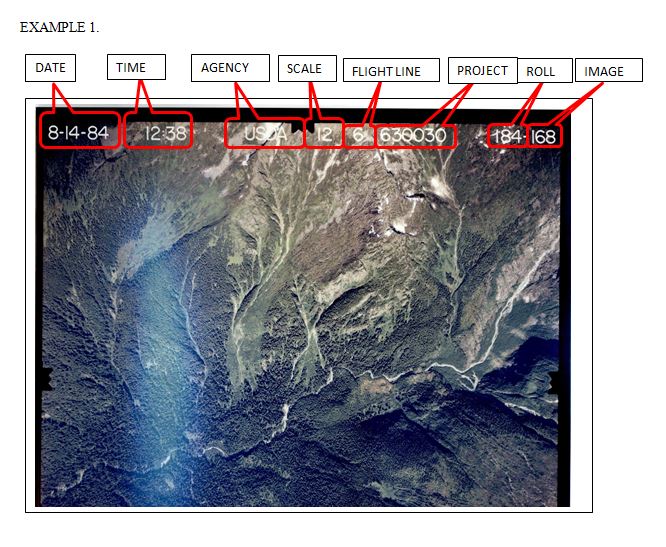
Aerial photographs in this collection have the following information printed on the front top edge. The order of the information may vary slightly.
DATE – Usually Month-Day-Year.
TIME - Occurs sometimes but not usually
AGENCY – Federal agency for which the photographs were taken: U.S. Department of Agriculture (USDA) or U.S. Forest Service (USDA-F)
SCALE – 12 (1:12,000) or 16 (1:16,000). These scales are expressed as representative fractions. A scale of 1:12,000 means 1 unit on the photo is equivalent to 12,000 units on the ground. A representative fraction of 1:12,000 has an English equivalency of 1" = 1,000'. A representative fraction of 1:16,000 has an English equivalency of 1"=1,333'. Note: The scale denoted “16” is actually 1:15,840, according to Forest Service image catalogs such as: http://www.fsa.usda.gov/Internet/FSA_File/fs_catalogpdf.pdf
FLIGHT LINE NUMBER – Corresponds with the flight lines shown on the index map. May begin or end with letters.
PROJECT NUMBER – The federal agency project number under which the photographs were produced. Sometimes the project number is printed without separation between it and the flight line number. Project numbers included in this collection are: 02220, 610020, 610021, 610030, 620030, 630030, 610022A, 610022B, 610022C, 610051A, 610052A, and 610054A.
ROLL NUMBER & IMAGE NUMBER – Correspond with points shown on the index maps. Image number may also be called frame number.

Research Guides by Egan Library | University of Alaska Southeast are licensed under CC BY-SA 4.0![]()
![]()
![]()